Geomorphology
| I | INTRODUCTION |

Slope Development
Landforms and landscapes change over time as a result of various dynamic factors. These factors include tectonic movement, weather, erosion, and gravity. At any given moment, a landscape may include one or more of the features shown.
© Microsoft Corporation. All Rights Reserved.
Geomorphology, scientific study of landforms and landscapes. The term usually applies to the origins and dynamic morphology (changing structure and form) of the earth's land surfaces, but it can also include the morphology of the seafloor and the analysis of extraterrestrial terrains. Sometimes included in the field of physical geography, geomorphology is really the geological aspect of the visible landscape. The science has developed in two distinctive ways that must be integrated in order for the whole picture of landscapes to emerge.
| II | HISTORICAL GEOMORPHOLOGY |
One approach to the science of landforms is by means of historical, cyclic geomorphology. The concepts involved were worked out at the turn of the 20th century by the American geologist William Morris Davis, who stated that every landform could be analyzed in terms of structure, process, and stage. The first two are also treated by process geomorphology, discussed below; but the third, by introducing the element of time, is subject to a far greater degree of interpretation. Davis argued that every landform underwent development through a predictable, cyclic sequence: youth, maturity, and old age.
Historical geomorphology relies on various chronological analyses, notably those provided by stratigraphic studies of the last 2 million years, known as the Quaternary period. The relative chronology usually may be worked out by observation of stratigraphic relationships, and the time intervals involved may then be established more precisely by dating methods such as historical records, radiocarbon analysis, tree-ring counting (dendrochronology), and paleomagnetic studies. By applying such methods to stratigraphic data, a quantitative chronology of events is constructed that furnishes a basis for calculating long-term rates of change.
| III | PROCESS GEOMORPHOLOGY |
This second branch of geomorphology analyzes contemporary dynamic processes at work in landscapes. The mechanisms involved—weathering and erosion—combine processes that are in some respects destructive and in others constructive. The bedrock and soil provide the passive material, whereas the climatic regime and crustal dynamics together provide the principal active variables.
| IV | UNDERLYING DYNAMICS |

Folded Rocks
Geomorphologists study the shape of the earth’s surface and the various processes that change the landscape. For example when large pieces of the earth’s crust move laterally, they create huge compressional forces that can bend or even break rocks. Here, the sedimentary rock layers show an anticlinal fold, in which the layers bend downward from the crest.
V. Englebert/Photo Researchers, Inc.
In geomorphological processes, gravity is an all-pervading, essentially invariable energy factor; a second variable, energy flow is provided by solar radiation. The latter is expressed either as a direct thermal variable or, indirectly, through the hydrologic cycle, which involves evaporation of water from the ocean, atmospheric transport of water, precipitation as rain or snow, and a return to the ocean by various processes. A third energy factor is heat flow from the earth's interior. Although of a magnitude considerably less than solar energy, this heat flow ultimately is responsible for creating major geological structures such as faults, but rates of change tend to be quite low (usually less than 1 mm per year). Nonetheless, in particular zones—for example, along crustal-plate boundaries (see Plate Tectonics) such as the San Andreas fault—stress may build up until released catastrophically in violent displacements of up to 12 m (40 ft). Locally, heat flow from the interior is concentrated in eruptions of magma (molten rock), which produce a variety of volcanic landforms.
| V | WEATHERING AND EROSION |
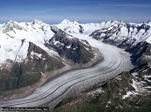
Glacial Erosion
Glaciers, such as this icy formation in Switzerland, erode the land over which they move. Glacial erosion is caused by distinct processes, such as abrasion, crushing, and fracturing of the glacier. Climate changes affect the size of glaciers, and glaciers move by growing or shrinking depending on the climate. Moving glaciers erode and transport large quantities of rocks, sand, and other particles along their path. Glacial erosion processes form features such as hanging valleys, moraines, cirques, horns, and scoured rock faces.
Paolo Koch/Photo Researchers, Inc.
Weathering is often a combination of three processes: the mechanical process, as in the growth of ice or salt crystals or in thermal heating and cooling; the chemical process, as in acid-water solutions that tend to dissolve minerals such as calcite and feldspar; and the biological process, as in the effect of plant roots, which generate both mechanical and chemical energy. Erosion is the dislodging, removal, and transport of material, either in solution or in particle form. The energy to accomplish this may be provided in the form of raindrops, running water, wind, waves, or simply gravity (as in a landslide).
An eroding landmass tends to rise to compensate for the removal of the load, but it eventually stabilizes as land relief decreases and stream gradients decline. The resulting surface, almost flat, is called a peneplain. It may be interrupted, here and there, by isolated hills called monadnocks consisting of rocks especially resistant to erosion. The theoretical base level of such a surface—the ultimate grade of streams—is mean sea level. For a peneplain to form and not be destroyed by renewed erosion, sea level must remain stable for millions of years. However, since the end of the Quaternary Ice Age, 10,000 years ago, sea level has risen hundreds of feet.
Human-induced soil erosion is a feature of the present day and of the last few millennia, because clearing land of native vegetation or excessive grazing by domesticated animals exposes the soil to massive erosion. In this way some 3 billion metric tons of particulate material are washed from the surface of the U.S. alone each year. In undisturbed natural settings, on the other hand—notably in low-relief continental interiors—erosion rates are very slow (except in semiarid areas where thunderstorms produce flash floods). In structurally active belts such as in youthful mountains, which as a rule coincide with plate boundaries that recently collided or rifted, erosion rates may be enormous.
Of all the different processes acting on the earth's surface, rain and rivers are the most vigorous erosive agents. By contrast, although wave action on a rocky coast is often impressive, the rate of retreat of the shoreline is generally very slow. Sand dunes in the Sahara are also impressive, but the sand is only a relatively thin veneer; and the moraines left by giant continental glaciers are likewise only superficial scrapings of ancient soils. In general, without human interference, the landscape is stable.
Contributed By:
Rhodes W. Fairbridge
Microsoft ® Encarta ® 2007. © 1993-2006 Microsoft Corporation. All rights reserved.


0 komentar:
Posting Komentar